The study of Earth and its people is called geography.
Continents
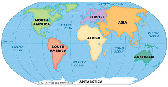
Earth is divided into seven large landmasses called continents . You can see the seven continents on the map below. From largest to smallest, the continents are Asia, Africa, North America, South America, Antarctica, Europe, and Australia.
Earth is divided into seven large landmasses called continents . You can see the seven continents on the map below. From largest to smallest, the continents are Asia, Africa, North America, South America, Antarctica, Europe, and Australia.
Hemispheres, Longitude, and Latitude
Hemispheres
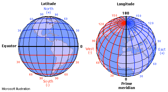
To study Earth, geographers divide the globe into equal halves. Each half is called a hemisphere. An imaginary line called the equator divides the globe into north and south halves. The half of Earth north of the equator is called the Northern Hemisphere. The half south of the equator is called the Southern Hemisphere.
Geographers use another imaginary line to divide Earth east from west. This line is called the prime meridian. The half of Earth west of the prime meridian is called the Western Hemisphere. The half east of the prime meridian is called the Eastern Hemisphere. The United States is located in the northern and western hemispheres.
Latitude and Longitude
Latitude (shown as a horizontal line) is the angular distance, in degrees, minutes, and seconds of a point north or south of the Equator. Lines of latitude are often referred to as parallels.
Longitude (shown as a vertical line) is the angular distance, in degrees, minutes, and seconds, of a point east or west of the Prime (Greenwich) Meridian. Lines of longitude are often referred to as meridians.
Distance between Lines If you divide the circumference of the earth (approximately 25,000 miles) by 360 degrees, the distance on the earth's surface for each one degree of latitude or longitude is just over 69 miles, or 111 km. Note: As you move north or south of the equator, the distance between the lines of longitude gets shorter until they actually meet at the poles. At 45 degrees N or S of the equator, one degree of longitude is about 49 miles.
Minutes and Seconds For precision purposes, degrees of longitude and latitude have been divided into minutes (') and seconds ("). There are 60 minutes in each degree. Each minute is divided into 60 seconds. Seconds can be further divided into tenths, hundredths, or even thousandths.
Maps
Different Maps for Different Purposes
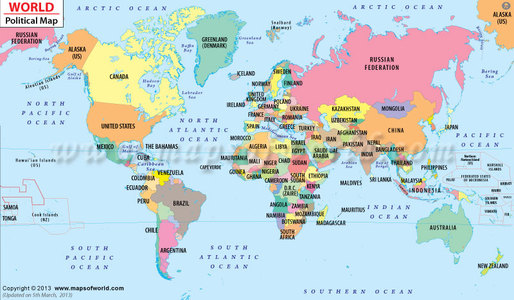
Different maps help us see different things. The two basic types of maps are political maps and physical maps.
Different maps help us see different things. The two basic types of maps are political maps and physical maps.
|
Political Maps
Political maps show the features people have created, such as cities, states, provinces, territories, and countries. State and country boundaries can also be outlined on these types of maps. A political map of a smaller area, such as a state, often shows county boundaries. Here are some of the questions the features of a political map, like the one below, might help you answer:
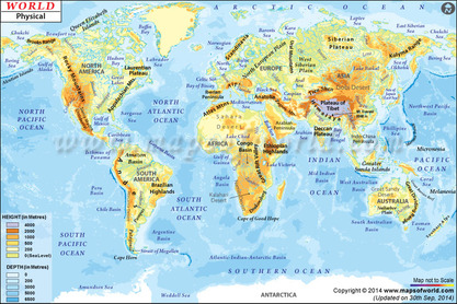
Physical Maps On a physical map, you can see what Earth's surface might look like from space. Physical maps show the land forms and bodies of water found in particular areas. Colors are often used to show elevations. On the map above, for example, brown indicates higher, more mountainous areas. Green shows areas that are relatively flat. |
Reading a Map
Most maps have nine features. These features, described below, help you read and understand maps.
|
Title The title tells the subject of the map and gives you an idea of what information is shown.
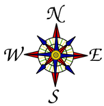
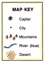
Compass rose The compass rose shows directions: north, south, east, and west. Symbols Symbols represent such items as capital cities and natural resources. The map legend explains what the symbols mean. Key or Legend The legend, or key, lists and explains the symbols and colors used on the map. Lines of longitude These are imaginary lines that measure distances east and west of the prime meridian. Lines of latitude These are imaginary lines that measure distances north and south of the equator. Scale A scale can be used to figure out the distance between two locations on a map. Labels Labels indicate the names of cities, land-forms, and bodies of water. Colors Colors represent a variety of information on a map. The map legend explains what the colors mean. |
The BBC has created some great tools to learn about Geography Skills and Atlas Skills. Click here for map activities or geography skills. Visit the BBC Student Site for more interactive learning and videos about Physical Geography, Human Geography, and the Environment.
How well do you know your world geography? Play this game to find out!
